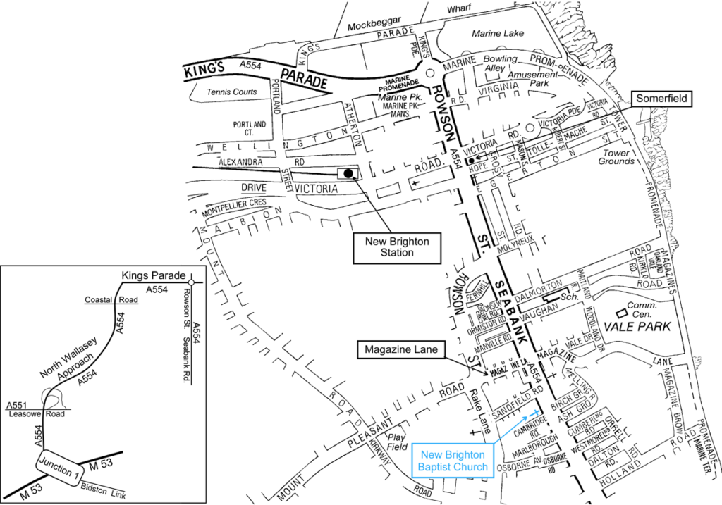
85a Allerton Road, Mossley Hill, Liverpool L18 2DA
Click here for Google Map | Click here to view our Map
By Bus
a) From Liverpool City centre
Bus no. 80: Liverpool One Bus Station stand 7, Hanover Street or Great Charlotte Street
Bus no. 86, 86 A + 86 D : Liverpool One Bus Station stand 9, Hanover Street or Elliott Street.
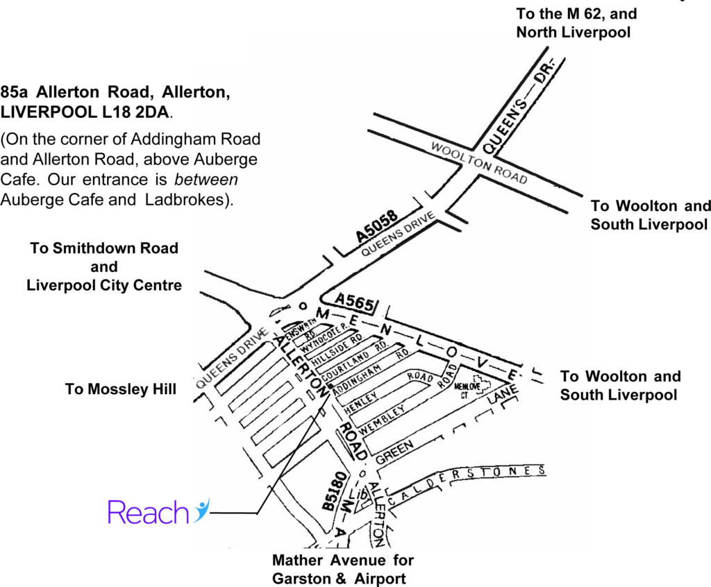
On Allerton Road, alight at the second bus stop after Queens drive. There is a roundabout and a set of traffic lights at this junction. The HSBC bank is on the corner on the left. The second bus stop is just after Costa Coffee. Walk back to Reach (about 125 metres) Please note: some buses don’t stop at Costa but continue round the corner to the next bus stop in Green Lane.
Bus no. 86 C : Liverpool One Bus Station stand 9, Hanover Street or Elliott Street.
This bus goes to Menlove Avenue. Alight at the corner of Addingham Road (second bus stop on Menlove Avenue). Cross the road and walk down Addingham Road to the corner of Allerton Road.
Reach is situated on the corner of Addingham Road and Allerton Road, above Auberge Cafe, which is
next door to the Ladbrokes Betting Shop. Our entrance is between Auberge cafe and Ladbrokes. Iceland is situated almost opposite across Allerton Road.
b) From Bootle Bus Station, Washington Parade
Bus no. 68: via Rice Lane, Tuebrook and Old Swan to Allerton Road (See above)
Bus no. 61: via Walton Vale, Broadway Old Swan and Childwall to Allerton Road.
Bus no. 81: via Walton, along Queens Drive. Alight at Childwall Fiveways, by Nat West Bank.
Get on the 61 bus at the same stop and alight at Allerton Road. For return journey change buses
on Childwall Priory Road. (This is a quicker route than the 61)
From the M62
At the Liverpool end of the M62, take the slip road left and follow signs for Garston and the Airport.
This takes you on to Queens Drive. Go straight through a major set of traffic lights and onto a roundabout
(Childwall Fiveways) where you take the third exit. Continue through another set of lights to the next roundabout. Take the second exit here and move straight away into the inside lane to turn left into Allerton Road at the traffic lights.
Reach is at the end of the fourth block of shops on the left, on the corner of Addingham Road, above the Auberge Cafe.
As Addingham Road is ‘No Entry’ at this point, you would be advised to turn into Courtland or Henley Road to park.
Please note that Kings House is not yet open for face to face counselling, so sessions will either be by phone or in Liverpool.
Kings House, Sidney Street, Manchester M1 7HB
Click here for Google Map | Click here to view our Map
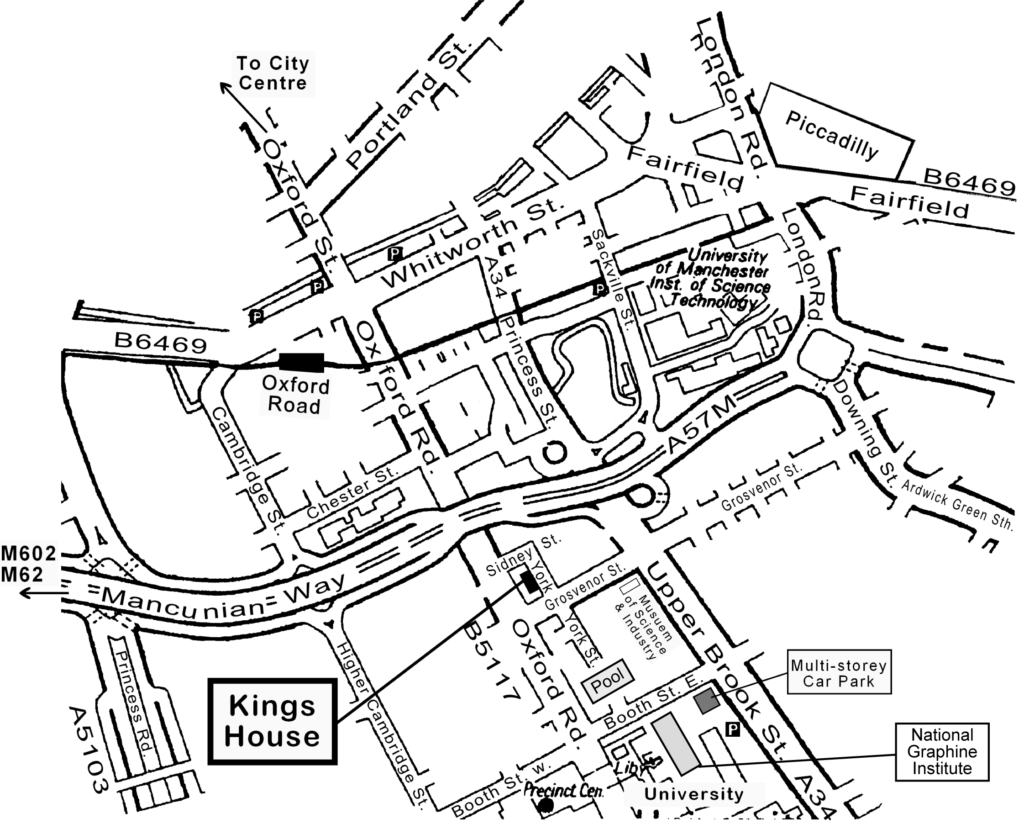
If you are coming along Grosvenor Street, go to the lights at Oxford Road and turn right by Barclays Bank. (This is because York Street is one way.) Take the first right again at the next set of lights onto Sidney street. Follow Sidney Street round, which then becomes York Street. Kings House is then on your right.
If you need further directions please phone 0161 273 2168. For any other information please contact our main office on 0151 737 2121
Kingsway Chapel, Kingsway, Newton, Chester CH2 2LH
Click here for Google Map | Click here to view our Map
By Bus
No 53 from Chester Town Hall (bus station)
Every 15 minutes. The journey takes approximately 10 – 12 minutes.
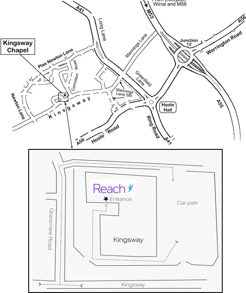
Alight at the shopping centre and walk back
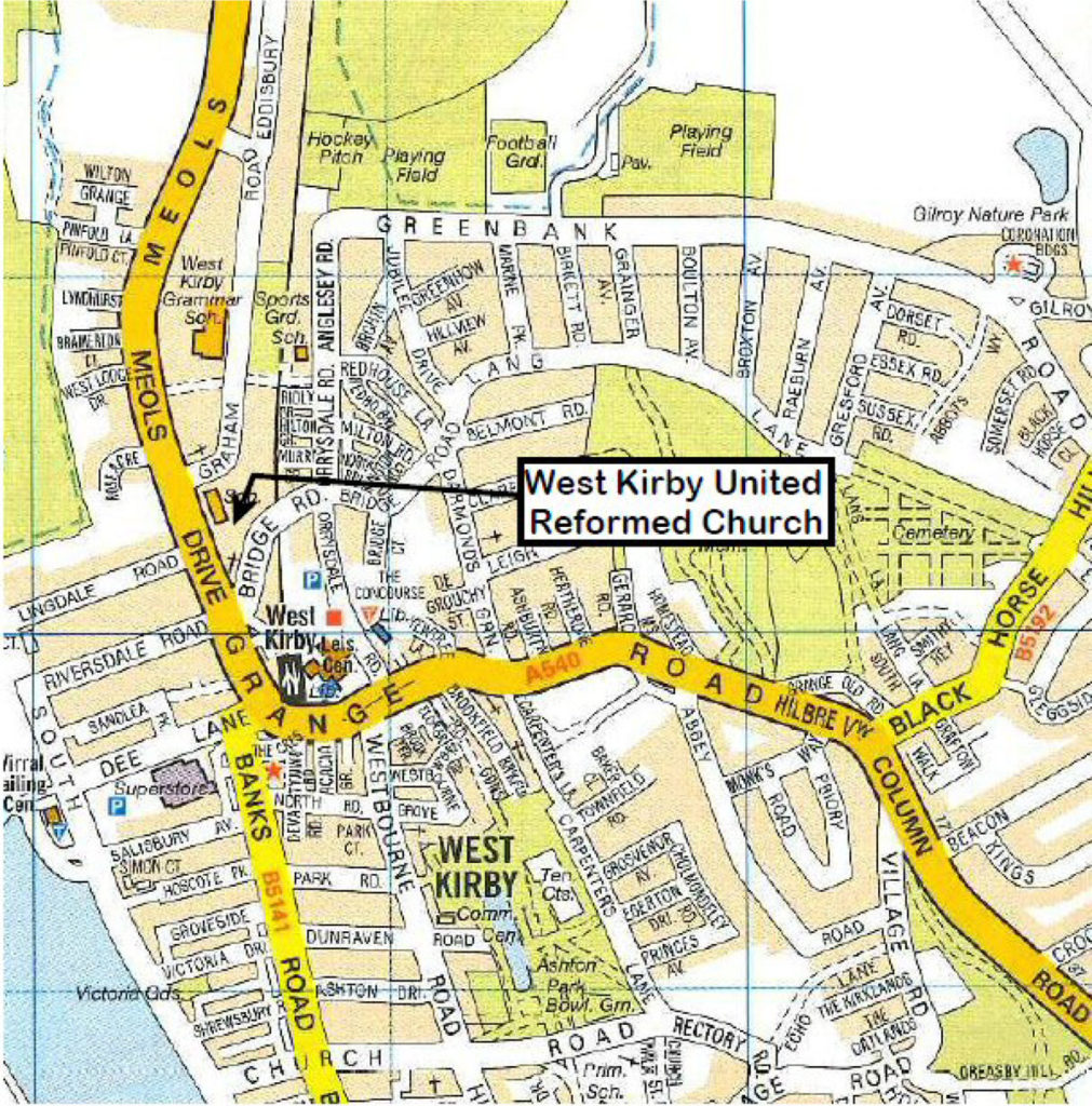
West Kirby United Reformed Church, Meols Drive, West Kirby, CH48 5DA
Click here for Google Map | Click here to view our Map
West Kirby URC is the red-brick church situated at the corner of Meols Drive and Bridge Road, near Aldi. A number of buses stop immediately opposite the church, and West Kirby’s main bus stops and train station are a few minutes’ walk away.
St. Thomas Philadelphia, Cross Gilpin Street, Sheffield, S6 3BL
Click here for Google Map
The entrance for the 1st Floor Counselling Room is via St Thomas Philadelphia’s reception on the corner of Gilpin Street and Cross Gilpin Street. Please press the buzzer for access and you will be met at the top of the stairs.
Travel directions:
By Car
St Thomas’ Church Philadelphia is located between the A61 Penistone Road and Infirmary Road. Coming from the Shalesmoor roundabout, take the first left after the petrol station.
By Tram
From the city centre or train station you can get a tram to either Malin Bridge or Middlewood. Get off at the Infirmary Road stop and St Thomas is on the road on right.
By Bus
No 82: Start from Snig Hill – runs along Infirmary Road
No 57: From Flat Street – runs along Infirmary Road
Nos 79 and 79a: From Flat St – both run along Penistone Rd
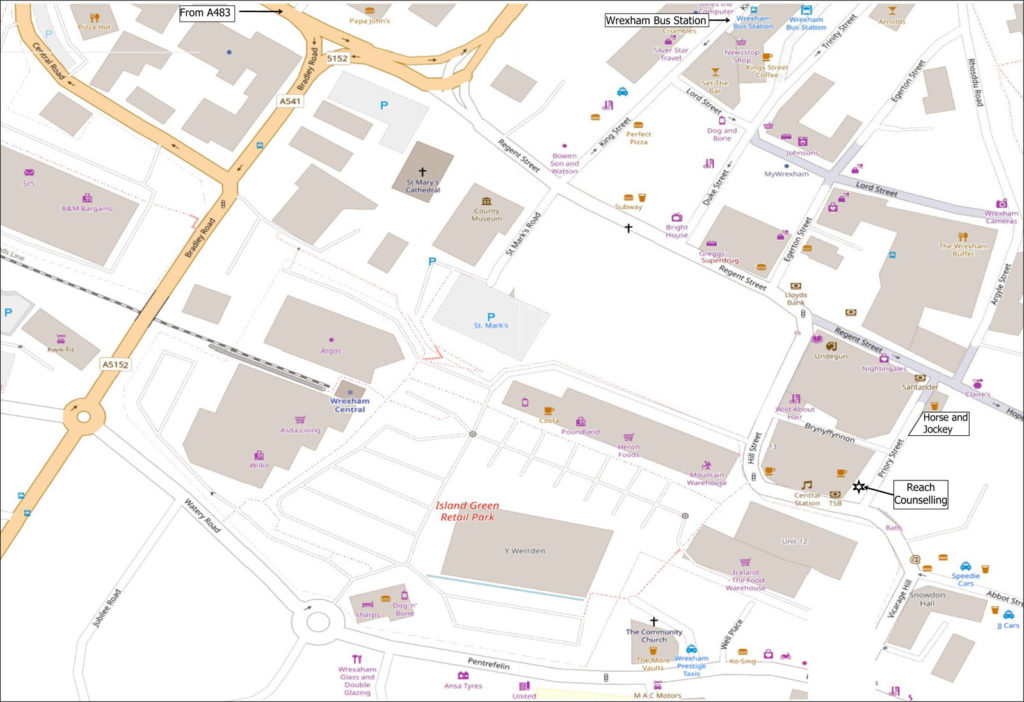
Reach at The Priory Offices, 12 Priory Street, Wrexham, L11 1SU
Click here for Google Map | Click here to view our Map
The counselling room is located in Priory Offices, 12 Priory Street. Priory Street is just off the pedestrian area, down from the distinctive white Horse and Jockey Pub and Santander bank at one end; and round the corner from Lloyds Bank at the other.
This is a 3 minute walk from the bus station. Walk along King street to Regent Street, then turn left and walk to Priory Street. The nearest public car park is in Island Green Shopping Park.
Ring the bell and you will be welcomed into the reception area. Access is up three shallow steps, but all on one level after that.


